Olongapo SubicBay BatangGapo Newscenter

Thursday, July 28, 2011

PAGASA lowered public storm warning signal, BUT this blogger believes that Olongapenos SHOULD brace for anticipated FLOODING

Be ready for flooding, may not be as bad as Ondoy but could be somewhere near it.

Olongapo City 1 – 3 Day Weather Forecast Summary: Heavy rain (total 278mm), heaviest during Fri night, Wind will be generally light.

250mm and above precipitation means flooding in our city.


While PAGASA Enhanced Satellite Image and Track of Storm Juaning indicate lesser disturbance prompting them to lower storm warning signals. This observer believe that such public announcement can be detrimental to our constituency in Olongapo City because people may lower their guards thinking that the worst is over.....

PAGASA's focus is on the strenght and movement of the storm. This writer's focus is on anticipating the volume of water that will pour in Olongapo City, a flood prone locality.

NASA's Tropical Rainfall Measuring Mission predicts that we will be flooded.


International Weather forecasts indicate that we will be flooded tomorrow afternoon til night.... I have been reading their forecast for years.... and this is one of the very few instances when a 97mm precipitation forecast was raised.

Tide charts are provided below for added reference.

PREDICTED HOURLY HEIGHT OF TIDE
Subic Bay, Zambales
Philippine Date: Thursday, July 28, 2011

HOUR
HEIGHT
HOUR
HEIGHT
2400
0.42
1200
0.45
0100
0.51
1300
0.25
0200
0.61
1400
0.09
0300
0.73
1500
-0.02
0400
0.86
1600
-0.06
0500
0.98
1700
-0.05
0600
1.07
1800
0
0700
1.11
1900
0.07
0800
1.08
2000
0.14
0900
1
2100
0.21
1000
0.85
2200
0.26
1100
0.66
2300
0.32

TimeHeightTimeHeight
ThuTide Set One07:34 AM1.23 m04:34 PM0.04 m
Tide Set Two
FriTide Set One08:22 AM1.31 m05:10 PM-0.01 m
Tide Set Two
SatTide Set One09:08 AM1.36 m05:43 PM-0.03 m

Disaster Risk Reduction Management Personnel and Rescue operatives should be placed on heightened alert.

Constituents MUST be fairly warned.

Better be safe than sorry...

Labels: , , , , ,

Tuesday, July 26, 2011

PAGASA raised Public Storm Warning Signal #2

Tropical Storm "JUANING" has slightly intensified as it moves toward Quezon area and increases its threat to Southern and Central Luzon.

Winds of 61-100 kph is expected in at least 24 hrs

International weather forecasters predict heavy rains Wednesday.

Tide is high from two to nine in the morning, peaking at around 6am with 1.15 meter

Low lying flood prone areas are advised to take precautionary measures.

Classes suspended for elementary and high school level.

Olongapo City 1 – 3 Day Weather Forecast Summary: Heavy rain (total 185mm), heaviest during Wed afternoon, Warm (max 28°C on Thu morning, min 26°C on Tue night), Wind will be generally light

High TideLow Tide
TimeHeightTimeHeight
WedTide Set One06:44 AM1.15 m03:55 PM0.11 m
Tide Set Two
ThuTide Set One07:34 AM1.23 m04:34 PM0.04 m
Tide Set Two
FriTide Set One08:22 AM1.31 m05:10 PM-0.01 m

Labels: , , ,

Wednesday, July 06, 2011

Weather Forecast for Olongapo-Subic area

Expect rain showers the whole week, get those rain gears ready!!

Labels: , , ,

Thursday, June 23, 2011

Olongapo Weather Forecast Summary: Heavy rain (total 234mm), heaviest during Fri afternoon

From Mayor James Bong Gordon Jr.
June 24, 2011 Olongapo City ALL LEVELS of Schools NO CLASSES
Olongapo Weather Forecast Summary: Heavy rain (total 234mm), heaviest during Fri afternoon


High Tides on Friday 3:25pm and Saturday 5:34am
FriTide Set One05:23 AM0.69 m10:36 AM0.55 m
Tide Set Two03:25 PM0.65 m10:19 PM0.34 m
SatTide Set One05:45 AM0.80 m12:49 PM0.45 m
Tide Set Two05:10 PM0.52 m10:27 PM0.39 m
SunTide Set One06:13 AM0.90 m02:23 PM0.33 m
Tide Set Two07:54 PM0.44 m

Labels: , , , ,

Wednesday, June 22, 2011

Flood Alert Raised for Olongapo-Subic areas

Flood Alert: Rainfall today up to tomorrow evening is 318mm, much higher than 266mm and 142mm when it flooded Olongapo City for two days just recently. Please be prepared. God bless everyone!
Olongapo 1 – 3 Day Weather Forecast Summary: Heavy rain (total 318mm), heaviest during Thu afternoon, (max 28°C on Wed morning, min 26°C on Wed night),
High tides:
Wednesday at 1:42pm - .96 m
Thursday at 2:26pm - .81 m

Labels: , , , , ,

Tuesday, June 21, 2011

Forecast: Heavy rain (total 142mm), heaviest during Wednesday night

Current report from weather-forecast.com said that there is going to be heavy rain (total 142mm), heaviest during Wednesday night.... but forecast provided by NASA Tropical Rainfall Measuring Mission indicate a more heavier precipitation at 250mm
By experience, precipitation that is more than 250mm is enough to trigger flooding in low-lying areas of Olongapo City. In the other day's forecast both sources predicted more than 250mm... and true enough... the city was flooded yesterday.
Present actual condition: heavy rains (almost the same as yesterday when it flooded) but this blogger's gut feel.... may flood the lowest points in the city but not enough to bring flood at yesterday's level.... but then again... with all bases loaded (high levels at our rivers)... its still best to be ready.

UPDATE as of 7pm: due to heavy rain coupled by high tide (1.5m) a few minutes past six this evening, flood were again experienced at various barangays of Olongapo starting 6:30pm. It was however not as deep as yesterdays flood.

Labels: , , ,

Sunday, June 19, 2011

Heavy rain expected in Olongapo-Subic area, heaviest during Sunday evening until Monday morning

Olongapo residents in flood-prone areas should prepare for possible flooding. Present conditions (including the heavy downpour last night) and forecasts from reputable sources indicate very high probability of flooding.
Olongapo 1 – 3 Day Weather Forecast Summary: Heavy rain (total 266mm), heaviest during Sunday evening until Monday morning
http://www.weather-forecast.com/locations/Olongapo/forecasts/latest

NASA Tropical Rainfall Measuring Mission

Labels: , , , ,

Thursday, June 09, 2011

Heavy rain in Olongapo-Subic (total 107mm), heaviest during Thurs night


http://www.weather-forecast.com/locations/Olongapo/map
NASA TRMM Image: Tropical Rainfall Measuring Mission
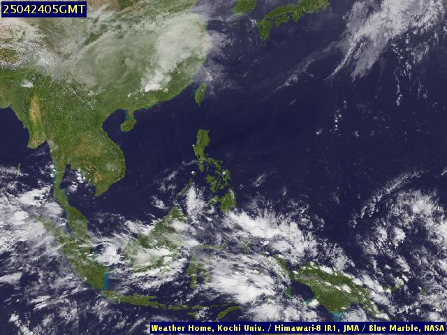
Image from the Japan Meteorological Agency.

Kochi University, Satellite Weather map


Labels: , , , , ,

Saturday, August 28, 2010

Rain and strong winds

A low-pressure area (LPA) west of Iba town in Zambales province has developed into a tropical depression, weather forecasters said Friday.

The tropical depression, “Florita,” is expected to enhance the southwest monsoon and bring rain and strong winds over the western sections of Luzon and the Visayas region, the Philippine Atmospheric, Geophysical, and Astronomical Services Administration (PAGASA) said.

PAGASA did not raise public storm warning signals over Luzon and the Visayas.

The state weather bureau’s website said that as of 4 p.m. Friday, “Florita” was located 330 kilometers west of Dagupan City and is expected to be 510 km west of Laoag City by Saturday afternoon.

The tropical depression is currently packing maximum winds of 55 kilometers per hour near the center and is expected to move northwest at 11kph.

PAGASA also spotted another low pressure area 770 km northeast of Basco, Batanes, today.

“The public and the disaster coordinating councils concerned are advised to take appropriate actions and watch for the next bulletin to be issued at 11 p.m. today,” PAGASA said.

Sat
28
morn-
ing
Sat
28
after-
noon
Sat
28
night
Sun
29
morn-
ing
Sun
29
after-
noon
Sun
29
night
Mon
30
morn-
ing
Mon
30
after-
noon
Mon
30
night
Wind (km/h)
Summary
rain shwrsrain shwrsrain shwrsrain shwrsrain shwrsrain shwrsrain shwrsrain shwrsrain shwrs
Rain (mm)
11174716118979

Heavy rain (total 135mm), heaviest during Saturday night, Warm
Precipatation forecast provided by

Present observation: continous rain this morning ranging from light to heavy

Labels: , , ,


This is a joint private blog of volunteers from Subic Bay. It is being maintained primarily to collate articles that may be of importance to decision making related to the future of Subic Bay and as a source of reference material to construct the history of Subic Bay.

The articles herein posted remains the sole property of original authors and publications which has full credits to the articles.

Disclaimer: Readers should conduct their own research and due diligence before using any article herein posted for whatever intended purpose it may be. This private web log will not be liable for any loss or damage caused by a reader's reliance on information obtained from volunteers of this private blog.

www.subicbay.ph, http://olongapo-subic.com, http://sangunian.com, http://olongapo-ph.com, http://oictv.com, http://brgy-ph.com, http://subicbay-news.com, http://batanggapo.com 16 January 2012